
Department of Geography, Environment & Geomatics
University of Guelph
I am an Assistant Professor in the Department of Geography, Environment & Geomatics at the University of Guelph. I completed my Ph.D. in Geomatics Engineering at the University of Calgary, where I was also a Postdoctoral Associate.
My research develops agentic GeoAI, in which large language model (LLM) agents plan, reason, and act over geospatial data grounded in Discrete Global Grid Systems (DGGS). A DGGS gives spatial operations a consistent frame across resolutions, which supports an operational Digital Earth. I build geospatial intelligence frameworks that integrate multi-source spatial data with machine learning and AI agents, and I apply them to environmental and climate modelling, including methane emissions monitoring, flood risk assessment, and environmental resilience. My research interests also include geospatial data science, spatial data infrastructure, and geospatial decision-support systems.
Education
- University of CalgaryDepartment of Geomatics Engineering
Ph.D. in Geomatics Engineering2023 - University of New BrunswickM.Sc. in Forestry2019
- Nanjing Forestry UniversityB.Sc. in Geographic Information Science2017
Experience
- University of GuelphDepartment of Geography, Environment & Geomatics
Assistant Professor2026 - present - University of CalgaryPostdoctoral Associate2024 - 2026
- Geosapiens Inc.Geospatial Scientist2023 - 2024
News All news
Selected Publications All publications
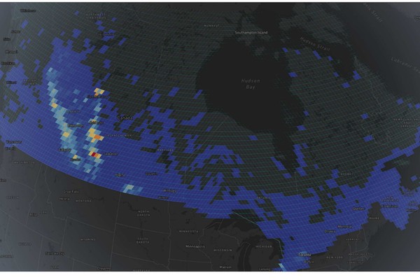
Enabling a Digital Earth for Methane Emissions Management with Equal-Area Discrete Global Grids
Li, M.E., Liang, S.H.L.
International Journal of Digital Earth, 19(1), 2607210. 2026
Abstract
We develop a spatially explicit methane inventory for Alberta’s upstream oil and gas sector using the rHEALPix Discrete Global Grid System. The objective is to demonstrate an equal-area, hierarchy-aware framework that assigns facility-reported emissions to native locations and supports multi-scale analysis and reporting. We compile monthly facility activity from Petrinex for 2020 to 2023, geolocate facilities using the Oil and Gas Infrastructure Mapping database, calculate methane emissions from venting, fuel use, and flaring using province-standard factors, and bin results to rHEALPix cells before exact aggregation to coarser levels. Our analysis revealed persistent high-emission hotspots, with 5% of grid cells accounting for 34% of total annual methane emissions. The equal-area lattice enables fair intensity comparisons across latitude, stable hotspot tracking over time, and mass-conserving aggregation that maintains consistent totals across resolutions. Practical implications include a standard spatial fabric that integrates facility reports, satellites, and ground sensors, provides persistent cell buckets for facility and asset management, enables accurate intensity comparisons across space and time with quantitative spatial resolution, preserves spatial integrity in visualization, supports consistent mass conserving aggregation at any scale with multiple granularities for analysis and reporting, allows precise hotspot tracking and trend monitoring, and informs targeted monitoring and survey design.Enabling a Digital Earth for Methane Emissions Management with Equal-Area Discrete Global Grids
Li, M.E., Liang, S.H.L.
International Journal of Digital Earth, 19(1), 2607210. 2026
Abstract
We develop a spatially explicit methane inventory for Alberta’s upstream oil and gas sector using the rHEALPix Discrete Global Grid System. The objective is to demonstrate an equal-area, hierarchy-aware framework that assigns facility-reported emissions to native locations and supports multi-scale analysis and reporting. We compile monthly facility activity from Petrinex for 2020 to 2023, geolocate facilities using the Oil and Gas Infrastructure Mapping database, calculate methane emissions from venting, fuel use, and flaring using province-standard factors, and bin results to rHEALPix cells before exact aggregation to coarser levels. Our analysis revealed persistent high-emission hotspots, with 5% of grid cells accounting for 34% of total annual methane emissions. The equal-area lattice enables fair intensity comparisons across latitude, stable hotspot tracking over time, and mass-conserving aggregation that maintains consistent totals across resolutions. Practical implications include a standard spatial fabric that integrates facility reports, satellites, and ground sensors, provides persistent cell buckets for facility and asset management, enables accurate intensity comparisons across space and time with quantitative spatial resolution, preserves spatial integrity in visualization, supports consistent mass conserving aggregation at any scale with multiple granularities for analysis and reporting, allows precise hotspot tracking and trend monitoring, and informs targeted monitoring and survey design.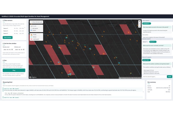
GridMind: A DGGS-Grounded Multi-Agent System for Spatial Reasoning
Li, M.E., Wang, J., Liang, S.H.L.
Proceedings of the 34th ACM International Conference on Advances in Geographic Information Systems (SIGSPATIAL '26) 2026
Abstract
Spatial reasoning depends on relations such as adjacency, containment, and hierarchy, while Large Language Models (LLMs) infer these relations unreliably from coordinates, maps, or text. Existing agentic GeoAI systems often address this limitation by reconstructing spatial relations for each query, without a persistent spatial substrate for reasoning. We present GridMind, a Discrete Global Grid Systems (DGGS) grounded multi-agent system that makes spatial relations a stable part of the architecture. To our knowledge, GridMind is the first system to use DGGS topology as a standing multi-agent substrate for spatial reasoning. It indexes space with DGGS and models both grid cells and spatial features as agents. Adjacency, hierarchy, and containment are derived from cell identifiers rather than inferred by the LLM. In the demonstration, users interact with an oil-and-gas asset-management sandbox to place sensors, replay leak events, observe selective sensor activation, and ask agents why and how they acted. GridMind shows that grid-grounded spatial relations can make multi-agent spatial reasoning explainable, scalable, and transferable to other DGGS-indexed domains.GridMind: A DGGS-Grounded Multi-Agent System for Spatial Reasoning
Li, M.E., Wang, J., Liang, S.H.L.
Proceedings of the 34th ACM International Conference on Advances in Geographic Information Systems (SIGSPATIAL '26) 2026
Abstract
Spatial reasoning depends on relations such as adjacency, containment, and hierarchy, while Large Language Models (LLMs) infer these relations unreliably from coordinates, maps, or text. Existing agentic GeoAI systems often address this limitation by reconstructing spatial relations for each query, without a persistent spatial substrate for reasoning. We present GridMind, a Discrete Global Grid Systems (DGGS) grounded multi-agent system that makes spatial relations a stable part of the architecture. To our knowledge, GridMind is the first system to use DGGS topology as a standing multi-agent substrate for spatial reasoning. It indexes space with DGGS and models both grid cells and spatial features as agents. Adjacency, hierarchy, and containment are derived from cell identifiers rather than inferred by the LLM. In the demonstration, users interact with an oil-and-gas asset-management sandbox to place sensors, replay leak events, observe selective sensor activation, and ask agents why and how they acted. GridMind shows that grid-grounded spatial relations can make multi-agent spatial reasoning explainable, scalable, and transferable to other DGGS-indexed domains.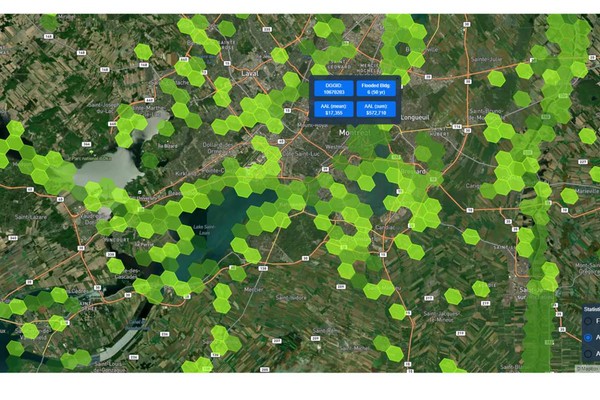
Utilizing serverless framework for dynamic visualization and operations in geospatial applications
Li, M., Tousignant, C., Chaudhuri, C., Chabbouh, A.
International Journal of Digital Earth, 17(1), 2392835. 2024
Abstract
While substantial efforts have been invested in the development of Discrete Global Grid Systems (DGGS) spatial operations and their potential applications in the geospatial domain, it has become evident that there is a demand for an efficient and scalable system to handle the visualization of large-scale DGGS data. This study demonstrated the potential of DGGS in conjunction with the serverless framework for dynamic visualization at various resolutions, which is based on data storage and effective querying using PostgreSQL integrated into Amazon Aurora Serverless. The use of Amazon Web Services (AWS) Lambda for on-the-fly generation of hexagon geometries significantly reduced the storage requirements and improved the speed of the visualization process. In addition, we implemented on-the-fly spatial operations including point binning, thresholding, aggregation, and neighborhood operations in the DGGS, highlighting the capabilities of DGGS in vector and raster processing. The proposed system has shown promising results in terms of efficiency, scalability, and adaptability, making it a viable solution for large-scale geospatial data processing and visualization. Case studies using flood risk data and terrain data further illustrate the system’s practical applicability in on-the-fly spatial operations and rapid visualization.Utilizing serverless framework for dynamic visualization and operations in geospatial applications
Li, M., Tousignant, C., Chaudhuri, C., Chabbouh, A.
International Journal of Digital Earth, 17(1), 2392835. 2024
Abstract
While substantial efforts have been invested in the development of Discrete Global Grid Systems (DGGS) spatial operations and their potential applications in the geospatial domain, it has become evident that there is a demand for an efficient and scalable system to handle the visualization of large-scale DGGS data. This study demonstrated the potential of DGGS in conjunction with the serverless framework for dynamic visualization at various resolutions, which is based on data storage and effective querying using PostgreSQL integrated into Amazon Aurora Serverless. The use of Amazon Web Services (AWS) Lambda for on-the-fly generation of hexagon geometries significantly reduced the storage requirements and improved the speed of the visualization process. In addition, we implemented on-the-fly spatial operations including point binning, thresholding, aggregation, and neighborhood operations in the DGGS, highlighting the capabilities of DGGS in vector and raster processing. The proposed system has shown promising results in terms of efficiency, scalability, and adaptability, making it a viable solution for large-scale geospatial data processing and visualization. Case studies using flood risk data and terrain data further illustrate the system’s practical applicability in on-the-fly spatial operations and rapid visualization.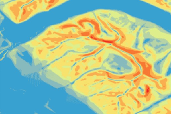
Multi-resolution topographic analysis in hexagonal Discrete Global Grid Systems
Li, M., McGrath, H., Stefanakis, E.
International Journal of Applied Earth Observation and Geoinformation, 113, 102985. 2022
Abstract
Discrete Global Grid Systems (DGGS) have been increasingly adopted as a standard framework for multi-source geospatial data. Previous research largely studied the mathematical foundation of discrete global grids, developed open-source libraries, and explored their application as data integration platforms. This study investigated the multi-resolution terrain analysis in a pure hexagonal DGGS environment, including descriptive statistics, topographic parameters, and topographic indices. Experiments across multiple grid resolutions were carried out in three study areas with different terrain roughness in Alberta, Canada. Five algorithms were proposed to calculate both the slope gradient and terrain aspect. A cell-based pair-wise comparison showed a strong positive correlation between the gradient values as calculated from five algorithms. The grid resolutions as well as the terrain roughness had a clear effect on the computed slope gradient and topographic indices. This research aims to enhance the analytical functionality of hexagonal DGGS to better support decision-making in real world problems.Multi-resolution topographic analysis in hexagonal Discrete Global Grid Systems
Li, M., McGrath, H., Stefanakis, E.
International Journal of Applied Earth Observation and Geoinformation, 113, 102985. 2022
Abstract
Discrete Global Grid Systems (DGGS) have been increasingly adopted as a standard framework for multi-source geospatial data. Previous research largely studied the mathematical foundation of discrete global grids, developed open-source libraries, and explored their application as data integration platforms. This study investigated the multi-resolution terrain analysis in a pure hexagonal DGGS environment, including descriptive statistics, topographic parameters, and topographic indices. Experiments across multiple grid resolutions were carried out in three study areas with different terrain roughness in Alberta, Canada. Five algorithms were proposed to calculate both the slope gradient and terrain aspect. A cell-based pair-wise comparison showed a strong positive correlation between the gradient values as calculated from five algorithms. The grid resolutions as well as the terrain roughness had a clear effect on the computed slope gradient and topographic indices. This research aims to enhance the analytical functionality of hexagonal DGGS to better support decision-making in real world problems.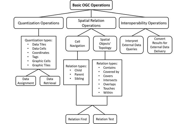
Geospatial Operations of Discrete Global Grid Systems – A Comparison with Traditional GIS
Li, M., Stefanakis, E.
Journal of Geovisualization and Spatial Analysis, 4(2), 26. 2020
Abstract
As the foundation of the next-generation Digital Earth, Discrete Global Grid Systems (DGGS) have demonstrated both theoretical and practical development, with a variety of state-of-the-art implementations proposed. These emerging DGGS platforms or libraries support preliminary operations such as quantization, cell-level navigation, and conversion between cell addresses and geographical coordinates, while leaving the other more complicated functions unexplored. This paper discusses the functional operations in a DGGS environment, including the essential operations defined by the Open Geospatial Consortium (OGC) Abstract Specification, and the extended operations potentially supported by DGGS. The extended operations are discussed in comparison to the traditional GIS, from the aspects of database techniques, data pre-processing and manipulation, spatial analysis and data interpretation, data computation, and data visualization. It was found that with the OGC-required operations and pre-processing operations as the baseline of development, some function algorithms can facilitate the algorithm development of other analytical functions. Several future research directions regarding the data modeling uncertainties, extended analytic algorithm development, and database and computation technologies are presented. This paper provides a comparison between DGGS and traditional GIS operations and can serve as a reference for future DGGS operation development.Geospatial Operations of Discrete Global Grid Systems – A Comparison with Traditional GIS
Li, M., Stefanakis, E.
Journal of Geovisualization and Spatial Analysis, 4(2), 26. 2020